
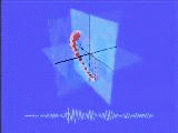
 Particle Motion (600k mpeg) of a
teleseismic event (distant earthquake) recorded at the
SMU TXAR array in
Lajitas, Texas. (See also the
AFTAC Site)
Ground motion accelerations are measured in three directions: vertical, north-
south, and east-west. The data are displayed as a sphere moving in 3-space.
A one second "tail" of motion history is displayed as a series of trailing
spheres of decreasing radius. Vertical data are plotted beneath as a waveform
with a moving cursor.
Particle Motion (600k mpeg) of a
teleseismic event (distant earthquake) recorded at the
SMU TXAR array in
Lajitas, Texas. (See also the
AFTAC Site)
Ground motion accelerations are measured in three directions: vertical, north-
south, and east-west. The data are displayed as a sphere moving in 3-space.
A one second "tail" of motion history is displayed as a series of trailing
spheres of decreasing radius. Vertical data are plotted beneath as a waveform
with a moving cursor.
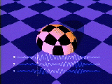 Deforming Ellipsoid (984k mpeg )
of the same teleseismic event as the above particle motion display.
In this case the data are used to model a deforming sphere, cut by a
plane which is divided into unity squares equal to the maximum excursion of
the north-south and east-west accelerations. All three waveforms are plotted
at the bottom of the screen with a moving cursor for temporal reference.
Deforming Ellipsoid (984k mpeg )
of the same teleseismic event as the above particle motion display.
In this case the data are used to model a deforming sphere, cut by a
plane which is divided into unity squares equal to the maximum excursion of
the north-south and east-west accelerations. All three waveforms are plotted
at the bottom of the screen with a moving cursor for temporal reference.
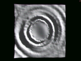
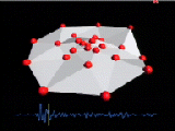 Polygonal Surface (1056k mpeg)
This data set is from a teleseismic event recorded at the
GERESS array in Germany.
The array consists of 25 one and three axis instruments arranged in four
concentric circles totaling about 5 km across. The array is modeled here as
red spheres which are joined by a surface of flat-shaded polygons.
Two of the instruments were switched off during this event. Note that
the central sphere appears to be out of phase with those nearby.
Polygonal Surface (1056k mpeg)
This data set is from a teleseismic event recorded at the
GERESS array in Germany.
The array consists of 25 one and three axis instruments arranged in four
concentric circles totaling about 5 km across. The array is modeled here as
red spheres which are joined by a surface of flat-shaded polygons.
Two of the instruments were switched off during this event. Note that
the central sphere appears to be out of phase with those nearby.
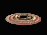
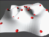 Spline Fit Surface (426k mpeg)
This model is from a regional seismic event (local small earthquake) near the
GERESS array in Germany.
The array consists of 25 one and three axis instruments arranged in four
concentric circles totaling about 5 km across. The seismic signal arrives
from the lower right corner of the image and propagates across the array toward
the upper left. The out of phase central station has been removed from this
model.
Spline Fit Surface (426k mpeg)
This model is from a regional seismic event (local small earthquake) near the
GERESS array in Germany.
The array consists of 25 one and three axis instruments arranged in four
concentric circles totaling about 5 km across. The seismic signal arrives
from the lower right corner of the image and propagates across the array toward
the upper left. The out of phase central station has been removed from this
model.

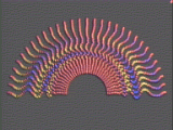 Shear Wave Model I (278k mpeg)
This data set was collected by Craig Pearson of Los Alamos National
Laboratory. The signal was generated by a pneumatic Shear Wave Impulse
Generator (SWIG) developed at SMU. It was sampled at 1302 locations by
single component transverse horizontal geophones arranged radially in a 56
meter half-circle. This movie models the data as colored spheres which
shift left/center/right in position and yellow/red/blue in color.
Shear Wave Model I (278k mpeg)
This data set was collected by Craig Pearson of Los Alamos National
Laboratory. The signal was generated by a pneumatic Shear Wave Impulse
Generator (SWIG) developed at SMU. It was sampled at 1302 locations by
single component transverse horizontal geophones arranged radially in a 56
meter half-circle. This movie models the data as colored spheres which
shift left/center/right in position and yellow/red/blue in color.
 Shear Wave Model II (235k mpeg)
This movie uses the same data as Shear Wave Model I. The half-circle data
points have been reflected to create a full 360 degree pattern, from which a
"splined" 3D surface was generated. Transverse motion is now represented as
vertical displacements of a smoothly varying curve.
Shear Wave Model II (235k mpeg)
This movie uses the same data as Shear Wave Model I. The half-circle data
points have been reflected to create a full 360 degree pattern, from which a
"splined" 3D surface was generated. Transverse motion is now represented as
vertical displacements of a smoothly varying curve.
 Shear Wave Model III (111k mpeg)
This visualization is a refinement of the 3D surface created in Model II.
The center and corners of the surface have been removed where no
data were collected. The color mapping scheme is similar to that used
in Model I, and the image has been rotated for an oblique view of the array.
The spline function used to create the surface has been allowed to "droop"
in order to more clearly see the geophone locations.
Shear Wave Model III (111k mpeg)
This visualization is a refinement of the 3D surface created in Model II.
The center and corners of the surface have been removed where no
data were collected. The color mapping scheme is similar to that used
in Model I, and the image has been rotated for an oblique view of the array.
The spline function used to create the surface has been allowed to "droop"
in order to more clearly see the geophone locations.
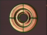 Shear Wave Model IV (210k mpeg)
An overhead view of the colored surface generated in Shear Wave Model III.
Bull's eye and cross-hair metrics have been added to help indicate the strong
asymmetry of the shear wave propagation. This effect is most marked if your
movie viewer provides single step access to the animation.
Shear Wave Model IV (210k mpeg)
An overhead view of the colored surface generated in Shear Wave Model III.
Bull's eye and cross-hair metrics have been added to help indicate the strong
asymmetry of the shear wave propagation. This effect is most marked if your
movie viewer provides single step access to the animation.
 SMU Geological Sciences
Archive
SMU Geological Sciences
Archive