Duncan Young
I am a graduate student (hailing from New Zealand) working on
that flat eighty percent of Venus lumped under the catagory 'plains' . Many
interesting questions can be asked about these 'background' regions of Venus'
suface, including:
- Can the relationships between the observed structural
features (dispersed and concentrated ridges, and fractures) and magmatic
features ('shield fields', large volcanoes, and the flows presumed to
comprise the plains) be delinated?
- If so, are the processes that create the said features
local, regional or global in extent?
- Are these processes constrained in time, or could they be
ongoing today?
- How do the plains relate to the other more scenic tectonic
provinces on Venus?
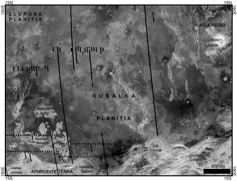
In particular, I am working in a
region of Venus named Rusalka Planitia. The southernmost portion of Rusalka
Planitia was mapped here as part of the 1:5 million scale VMAP program (specifically
on V37 Diana Chasma, DeShon and Hansen, submitted), and now I am working on the
heart of the planitia in the V25
quadrangle. As can be seen in the SAR (Synthetic Apeture Radar) image below,
Rusalka Planitia represents a typical region of plains marked by twisting
tectonic belts knotted with circular corona (especially
down on the southern edge); lava flows, craters, and craters with lava flows;
huge volcanoes (for example, Sapas Mons in the north east); and some nuggets of
torn-up tessera terrain in the south western corner. One feature to note here
is the scale bar at the bottom right; this image is easily the size of
Australia!
To aid my research, I have developed a set of macros for the
freeware image proccesing program NIH
Image. Image was developed by Wayne Rasband of the National
Institutes of Health as a public domain Macintosh tool for biomedicial
analysis, but has since found uses in fields as diverse as materials science
and volcanic monitoring. As the source code is public, many spin-off versions
have been developed, including Object
Image (sophisticated region-of-interest analysis), Scion Image (a PC
version of Image) and Steve Barrett’Äôs Image SXM (which has a
bunch of useful features originally intended for electron microscopes).
The original Magellan MIDR CD-ROMs included an earlier version
of Image reconfigured to allow the loading of Planetery Data System images in a
georeferenced format. While useful, 'Image PDS' had some limitations. So I
played around with the user definable macro utility and came up with some tools
compatible with later versions of Image that are useful for accessing and processing
the Magellan datasets from a Macintosh.
Functions include:
- Opens and calibrates GxDR (Global 'various geophysical'
Data Record) framlets
- Generates ('forges') custom sinusodal projections of GxDR
data.
- Opens MIDR (JPL Mosaiced Image Data Record) and FMAP (USGS
Full Resolution Image Maps) browse images with 'point and click' links to
individual framlets.
- Allows
reprojection from sinusoidal to simple cylindrical map projection, and simple
cylindrical to mercator
- Allows the creation of a custom FMAP framelet (for when all
the cool geology is on the corners of four framlets)
- Generates synthetic stereo anaglyphs from matching SAR and
topo
- Allows an entire FMAP to be tiled together at C1
resolution. First open an FMAP browse of interest to perform this
operation. (Note: Due to the resampling method used, the generated
image SHOULD NOT be used for quantitative analysis of
backscatter).
To use these macros, just go to
this link, unzip the file, and put it in the same folder as the Image
program (which you can download FREE from the above links-Scion probably won't
work with these macros, but Image SXM probably will). When you start Image, the new commands
will be found under the 'Special' menu. (You will probably want to crank up Image’Äôs memory allocation
to at very least 60 Mb and up the Clipboard size in Image’Äôs Preferences to
>10 Mb)
Feel free to modify and improve them.
Here are detailed discriptions of these macros
(slightly out of date!)
Magellan data is availible online at the Planetary Data
System.
Note: A cross-platform open source Java image processing
program, ImageJ, is currently being developed by Rasband. ImageJ should be even
more powerful than Image once finished! (And if I ever learn Java’Ķwell’Ķ.J)
My Education so far: B.Sc (Hons.) First Class in
Geology / University of Canterbury, Christchurch, NEW ZEALAND
If you have
comments or suggestions, email me at dyoung@mail.smu.edu
Click here to return to the Venus tectonics homepage...