
 GEOLOGICAL SCIENCES
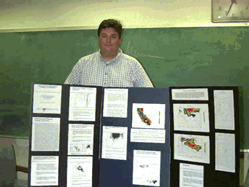 HEAT FLOW AND EARTHQUAKE SYNERGY IN CALIFORNIA
Jessie L. Bonner
Comparison of the heat flow and earthquake databases for California provides detailed geologic and geophysical information about the earthquake process. Using the high-quality databases for California seismicity (SCEC and NCEC) and the extensive compilation of thermal measurements in California (SMU Geothermal Lab), the temperature range for the maximum depth of seismicity has been established within workable error limits. Two different methods were employed to obtain this range. The first considered the entire heat flow and earthquake database for California, and the inverse relationship between heat flow and the cutout depth for seismicity is obvious. Temperatures for this depth were calculated using the steady-state, one-dimensional, heat conduction equation, assuming average values for heat generation and thermal conductivity. Temperatures range between 400 degrees C and 700 degrees C, higher than accepted rheologic models predict for continental crust. An alternative method considered temperature calculations for regions where the geologic, seismic, and thermal regimes are well constrained. By considering such profiles of collocated heat flow measurements and seismicity, we reduce the error in the temperature calculation to start at 0 degrees C at the surface and increase linearly +/-4.5 degrees C/km, as determined by the inner 900 of 1000 Monte Carlo simulations. Temperatures for the cutout depth range between 300 degrees C to 500 degrees C and 600 degrees C for profiles in Southern and Northern California, respectively. Differences in the temperatures may be the results of misassociation of the available heat flow and earthquake databases, contrasting rheologies, or other explanations including localized strain accumulations that need by investigated. Along profiles with significant seismic activity, the envelope for the maximum energy released by earthqukes follows the 300+/-100 degrees C isotherm. Detailing the heat flow and earthquake synergy in this manner allows estimating the depth of initial rupture for great earthquakes, thus reducing uncertainties in hazard calculations.

 STRUCTURAL ANALYSIS OF CENTRAL AND
EASTERN OVDA REGIO, VENUS
STRUCTURAL ANALYSIS OF CENTRAL AND
EASTERN OVDA REGIO, VENUS
Rebecca R. Ghent
Introduction. Ovda Regio is the largest of the Venusian crustal
plateaus and lies in Western Aphrodite Terra, Venus. Understanding the
strain history of this region will provide a key to understanding the
formation of Ovda Regio and will have implications for the formation of
other crustal plateaus.
Observations. We mapped tectonic features of Ovda Regio using
Magellan SAR images. The three major structures in Ovda Regio are
folds, "ribbons" and graben. Folds are present everywhere in Ovda
and have different characters in different regions. Graben are
lens-shaped depressions bounded by paired normal faults, and they
occur dominantly at the crests of folds. "Ribbons" are steep-sided,
flat-floored troughs, 1-3 km wide and spaced 1-5 km apart. They extend
for hundreds of km over vast areas of Ovda Regio. The folds are interpreted
to be contractional, and graben and ribbons extensional. Ribbons are
structurally quite different from the graben and therefore their
origins should be considered separately.
Implications.
Some workers have proposed that Ovda Regio records early contractional
strain (fold formation) and later extension (graben and "steep trough"
formation) [1]. We propose that ribbon formation predates, rather than
postdates, fold formation. Formation of ribbons before folds indicates
that the earliest recorded strain in Ovda Regio is broad radial
membrane extension, rather than contraction. This pattern of extension
is consistent with the idea that Ovda formed above a mantle plume [2,3].
Many of the same tectonic features present in Ovda have also been
observed in Alpha Regio [4], and it is therefore possible that Alpha
also records early extension. This would have important implications
for the formation of other crustal plateaus.
References.
[1] Binschadler et al., (1992a) JGR 97, 13495; [2] R.J. Phillips and
V.L. Hansen (1994) Ann. Rev. Earth Planet. Sci. 22, 597, 651;
[4] Binschadler et al., (1992b) JGR 97, 13563.
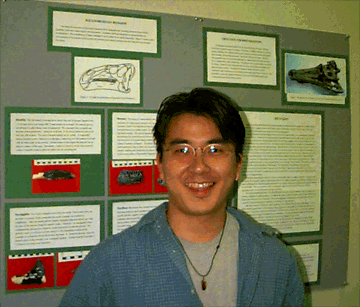
The nearly complete skull of a hadrosaur from the Cenomanian Woodbine
Formation (95 Ma) of northeast Texas is a mixture of derived
hadrosaurian and generalized iguanodontid characters. The premaxillae
form an expanded rostral bill, a wide diastema occurs between the
predentary and dentary tooth battery, and the maxillary teeth are
small. The jugal-ectopterygoid articulation and surangular foramen
are retained, and the quadrate is massive with poorly differentiated
mandibular condyles. The most striking features of the specimen are the
massive, expanded dentary and ventrally deflected muzzle.
Early Cretaceous (Aptian-Albian) archosaurs have been found from the
Kitadani Formation in Fukui, Japan. The formation yields iguanodontian
and crocodylomorph fossil remains. In this study, one nearly complete
skeleton of a crocodylomorph and cranial elements of iguanodontians
have been analyzed. The crocodylomorph is the most complete fossil
archosaur found in Japan, and shares a dental characteristic with
Bernissartia restricted to western Europe and possibly North
America. Iguanodontian materials are similar to those described from
European taxa: however, several characters indicate this is a new taxon.
The project is designed to characterize the regional variations in the
isotopic and chemical composition of the crude oils and formation
waters from the Upper Cretaceous Woodbine and Low Cretaceous Travis
Peak formations, East Texas basin. The overall goals of the study
are: 1) to reconstruct the diagenetic history of the waters, 2) to
discuss a possible bearing of local geological structures (salt domes,
fault zones, etc.) on the compositional variations, 3) to detect any
correlation between the composition of coexisting crude oil and formation
water, and 4) to determine if the oil and aqueous phase migrated together
from their source (source formation) to the trap (producing formation).
Geologic and geophysical evidence points to past and future great
earthquakes in the Pacific Northwest. The absence of seismicity along the
Cascadia margin makes characterization of rupture processes and maximum
moment magnitudes of great subduction zone earthquakes very difficult.
An alternative methodology for risk evaluation must be employed. A
series of one-dimensional temperature profiles parallel to convergence
were used to create a thermal cross section of the subduection zone,
determining the thermal state of the accretionary wedge near
45 degrees N, 125 degrees W. Different rheologis are then used to determine
the down-dip brittle-ductile transition of the main decollement. Limits
on the width of the seismogeneic (brittle) segment of these various
rheologies are used to assess the regional seismic hazard.
 A PRIMITIVE HADROSAUR (DINOSAURIA: ORNITHISCHIA) FROM THE
CENOMANIAN OF TEXAS AND ITS IMPLICATIONS FOR HADROSAURIAN
PHYLOGENETIC AND BIOGEOGRAPHIC HISTORIES
A PRIMITIVE HADROSAUR (DINOSAURIA: ORNITHISCHIA) FROM THE
CENOMANIAN OF TEXAS AND ITS IMPLICATIONS FOR HADROSAURIAN
PHYLOGENETIC AND BIOGEOGRAPHIC HISTORIES
Jason J. Head
Phylogenetic analysis places the specimen at the basal position within
Hadrosauridae. The age and location of the Texas hadrosaur along the
eastern coast of the Western Interior Seaway makes it the oldest
definitive hadrosaur from eastern North America, and indicates that
the suggested Turonian radiation of hadrosaurs from western Asia may
have occurred earlier elsewhere.
 ARCHOSAURS FROM THE KITADANI FORMATION
(APTIAN-ALBIAN), JAPAN
ARCHOSAURS FROM THE KITADANI FORMATION
(APTIAN-ALBIAN), JAPAN
Yoshitsugu Kobayashi
These remains from the Kitadani Formation indicate that the continuation
of western European fauna to eastern Asia. The similarity of the archosaur
faunas supports a previous hypothesis of a global-circular distribution of
European taxa and indicates a biogeographic connection between Japan and
mainland Laurasia during the Aptian-Albian. Further study will be focused
on the comparison with Chinese dinosaurian fauna during the same age.
 A COMINED ISOTOPE (C, O, H and Sr) AND
CHEMICAL STUDY OF CRUDE OILS
AND FORMATION WATERS FROM THE UPPER CRETACEOUS WOODBINE AND LOW
CRETACEOUS TRAVIS PEAK FORMATIONS, EAST TEXAS BASIN.
A COMINED ISOTOPE (C, O, H and Sr) AND
CHEMICAL STUDY OF CRUDE OILS
AND FORMATION WATERS FROM THE UPPER CRETACEOUS WOODBINE AND LOW
CRETACEOUS TRAVIS PEAK FORMATIONS, EAST TEXAS BASIN.
Vladimir V. Liakhovitch
The Upper Cretaceous Woodbine and Low Cretaceous Travis Peak formations
are the main oil-producing formations of the East Texas basin separated
by the regionally defined aquitard, the Ferry Lake Massive Anhydrite.
Our data confirm that the Upper Cretaceous and Low Cretaceous waters
differ in their chemical, radiogenic (Sr) and stable isotope (O, H and C)
composition and follow different evolutionary paths representing two major
hydrologic subsystems in the basin. The East Texas crude oils are of Upper
Cretaceous, Low Cretaceous and Jurassic origin. A combined geochemical and
isotope study of the crude oils and formation waters from the two
formations not only allows one to reconstruct the evolution and circulation
of the aqueous and oil phases in one of the world's largest continental
basins but also provides a unique opportunity to address a most intriguing
problem of petroluem geology: "Do formation waters reflect
reservoired oil?"
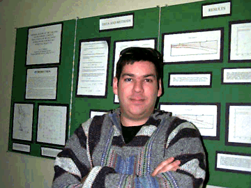 THERMAL CONSTRAINTS ON POTENTIAL CASCADIA SUBDUCTION ZONE
EARTHQUAKES NEAR 45 DEGREES N
THERMAL CONSTRAINTS ON POTENTIAL CASCADIA SUBDUCTION ZONE
EARTHQUAKES NEAR 45 DEGREES N
Jason R. McKenna
 THE GEMSTONE BEARING PEGMATITES OF KERALA, SOUTH INDIA
 ARRAY MEASUREMENTS OF TELESEISMIC P AND PcP SLOWNESS AND
AZIMUTH RESIDUALS WITH IMPLICATIONS FOR LATERAL HETEROGENEITY IN THE
LOWER MANTLE
ARRAY MEASUREMENTS OF TELESEISMIC P AND PcP SLOWNESS AND
AZIMUTH RESIDUALS WITH IMPLICATIONS FOR LATERAL HETEROGENEITY IN THE
LOWER MANTLE


